
Chile Weather, climate and geography
Weather & climate
Chile's climate varies dramatically from north to south due to its extraordinary length and changing geography.
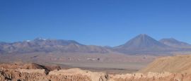
In the far north, the Atacama Desert is one of the driest places on Earth. Rain is extremely rare, and daytime temperatures typically range between 20–30°C (68–86°F) year-round, though nights can be cold, especially at altitude.
Central Chile, including Santiago and the wine regions, has a Mediterranean climate. Summer runs from December to February and is warm to hot, with temperatures commonly reaching 28–35°C (82–95°F). Winter lasts from June to August and is cooler, with daytime temperatures usually between 10–18°C (50–64°F). Rain falls mainly during the winter months.
Further south in the Lake District, the climate becomes cooler and wetter. Summers are mild, averaging 15–25°C (59–77°F), while winters are colder and rainy, with temperatures often between 4–12°C (39–54°F).
In Patagonia, conditions can be unpredictable throughout the year. Summer temperatures generally range from 10–20°C (50–68°F), but strong winds are common. Winters are cold, with temperatures frequently near or below freezing, especially inland.
On Easter Island, the climate is subtropical, with warm temperatures year-round, typically between 18–27°C (64–81°F), and moderate rainfall distributed throughout the year.
Clothing requirements in Chile depend largely on region and season.
For travel in central Chile during summer, lightweight clothing is suitable, though evenings can be cooler. In winter, warmer layers and a coat are necessary, particularly in Santiago, where temperatures drop after sunset.
In the Atacama Desert, lightweight clothing is appropriate during the day, but warm layers are essential at night due to significant temperature drops, especially in high-altitude areas.
For the Lake District and southern Chile, waterproof clothing is advisable year-round, as rain is frequent. Layered clothing is recommended to adapt to changing conditions.
In Patagonia, even during summer, visitors should be prepared for strong winds and sudden weather shifts. Windproof and waterproof outerwear, sturdy footwear and warm layers are essential.
On Easter Island, light clothing is generally suitable, but a light jacket or rain layer may be useful due to occasional showers and ocean breezes.
Overall, Chile's varied geography means travellers should pack according to the specific regions they plan to visit rather than assuming uniform conditions across the country.
Geography
Chile is one of the most geographically distinctive countries in the world. Stretching for over 4,000km (2,500 miles) along the western edge of South America, it is exceptionally long and narrow, averaging just about 180km (112 miles) wide. This unique shape creates dramatic variations in landscape and climate from north to south.
Chile shares borders with Peru to the north, Bolivia to the northeast and Argentina along its entire eastern frontier, which follows the spine of the Andes Mountains. To the west lies the vast Pacific Ocean.
The Andes dominate Chile's eastern edge, forming a natural boundary with Argentina. The country's highest point is Ojos del Salado at 6,893m (22,615ft), the highest volcano in the world. Chile's lowest point is sea level along its extensive coastline, which runs for more than 6,000km (3,700 miles) when including fjords and islands.
In the far north lies the Atacama Desert, one of the driest places on Earth, characterised by salt flats, volcanic peaks and high-altitude plateaus. Moving southwards, the land softens into fertile central valleys framed by mountains and ocean, where vineyards and agriculture flourish.
Further south, landscapes become increasingly rugged. The Lake District features snow-capped volcanoes and dense forests, while Patagonia is defined by glaciers, fjords, ice fields and windswept plains. Off the mainland, Chile also governs remote Pacific territories, including Easter Island, one of the most isolated inhabited islands in the world.
Chile sits along the Pacific "Ring of Fire", making it prone to earthquakes and volcanic activity. These powerful geological forces have shaped the country's dramatic terrain and continue to influence its landscape today.
Do you have any Feedback about this page?
© 2026 Columbus Travel Media Ltd. All rights reserved. No part of this site may be reproduced without our written permission, click here for information on Columbus Content Solutions.


 You know where