
Sierra Leone Weather, climate and geography
Weather & climate
The climate is tropical and humid all year. Between November and June, it is very hot and dry, although the coastal areas are cooled by sea breezes. In December, January and February the dry, dusty Harmattan wind blows from the Sahara. Rainfall can be torrential during the rainy season between May and November.
In March there are sporadic rains, accompanied by strong winds, in the provinces when the heat of the dry season reaches its peak. If you decide to travel to the provinces during the month of March, it is advisable to bring waterproof clothing to avoid getting drenched when you least expect it.
August has the most rainfall, and it is best avoided if you are looking for a sun-soaked holiday on Sierra Leone’s beautiful beaches, but it is also the time when wildlife activity is at its peak and therefore a period of the year that attracts a lot of nature lovers.
There are no restrictions on clothing for men or women, with casual attire such as sleeveless shirts, flip flops and sandals the norm. Lightweight and light-coloured, cotton clothing is recommended due to the hot and humid climate. During the rainy season, it is advisable to wear wet-weather clothing, while a light jersey or jacket may be needed in the months when the Harmattan winds blow.
Geography
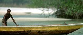
Sierra Leone is bordered to the northwest, north and northeast by the Republic of Guinea, and to the southeast by Liberia. To the south and southwest lies the Atlantic Ocean. A flat plain up to 110km (70 miles) wide stretches the length of the coast except for the Freetown peninsula, where the Lion Mountains rise to 888m (2,913ft). In some coastal areas, sand bars have formed that stretch out as far as 112km (70 miles). Behind the coastal plain is the central forested area, drained by eight principal rivers, which has been cleared for agriculture. The land rises in altitude eastwards to the Guinea Highlands, a high plateau with peaks rising to over 1,830m (6,000ft) in the Loma Mountains and Tingi Hills area. The Mende tribe is prominent in the southeast and the Temne in the western and northern areas.
Do you have any Feedback about this page?
© 2026 Columbus Travel Media Ltd. All rights reserved. No part of this site may be reproduced without our written permission, click here for information on Columbus Content Solutions.


 You know where