
Egypt Weather, climate and geography
Weather & climate
Egypt has a desert climate, with hot summers, mild winters and very little rainfall. The best time to visit is from October to April, when temperatures are generally more comfortable for sightseeing, particularly in Cairo, Luxor and Aswan. During these months, daytime temperatures are warm rather than extreme, while evenings can be cooler, especially between December and February.
In spring, typically between March and May, Egypt may experience occasional hot, dry desert winds known as the khamsin. These winds can cause short-lived spikes in temperature and dusty conditions, particularly in the Nile Valley, but they are usually brief and do not last more than a day or two. The summer months, from May to September, can be extremely hot, especially in Upper Egypt and desert regions, where temperatures often exceed 40°C. Coastal areas along the Mediterranean and Red Sea are moderated by sea breezes and are generally more tolerable during this period. Rainfall is minimal throughout the year, with only occasional winter showers along the Mediterranean coast.
Lightweight, breathable clothing is recommended for most of the year, particularly during the warmer months. Natural fabrics such as cotton and linen are well-suited to Egypt's climate. A light jacket or jumper may be useful during winter evenings, especially in desert areas or along the Nile.
Modest dress is important in public spaces, particularly outside resort areas and when visiting religious sites. Both men and women should cover their shoulders and knees, and women may wish to carry a scarf for mosque visits. Comfortable walking shoes are essential for sightseeing, while sun protection, including a hat and sunglasses, is strongly advised.
Geography
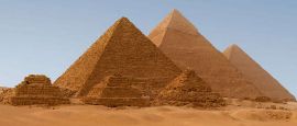
Egypt occupies a strategic position at the crossroads of northeast Africa and the Middle East, bordered by the Mediterranean Sea to the north and the Red Sea to the east. To the west lies Libya, to the south Sudan, and to the northeast Israel and the Gaza Strip. Despite its large size, the vast majority of Egypt's population lives within a narrow strip of land along the Nile River and its delta, where fertile soil supports agriculture and settlement.
The Nile River is the defining geographic feature of the country, flowing from south to north for more than 1,500 kilometres within Egypt before emptying into the Mediterranean. Its annual flooding, now controlled by the Aswan High Dam, historically shaped farming cycles and sustained ancient civilisation. Beyond the Nile Valley and Delta, most of the country is desert, divided between the Western Desert, which forms part of the Sahara, and the Eastern Desert, a rugged landscape of mountains and wadis stretching to the Red Sea.
Egypt can be broadly divided into four geographic regions: the Nile Valley and Delta, the Western Desert, the Eastern Desert, and the Sinai Peninsula. The Sinai is mountainous and sparsely populated, acting as a land bridge between Africa and Asia. Along the Red Sea coast, coral reefs and clear waters contrast sharply with the arid interior, while the Mediterranean coast in the north has a milder climate and more fertile farmland. This diversity of landscapes helps explain Egypt's long-standing role as both a natural corridor and a cultural meeting point.
Do you have any Feedback about this page?
© 2026 Columbus Travel Media Ltd. All rights reserved. No part of this site may be reproduced without our written permission, click here for information on Columbus Content Solutions.


 You know where