
Djibouti Weather, climate and geography
Geography
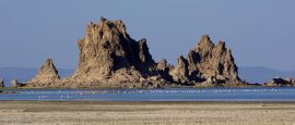
Djibouti is part of the African continent, bordered to the northeast and east by the Red Sea, the southeast by Somalia, the southwest by Ethiopia and to the north by Eritrea. The country is a barren strip of land around the Gulf of Tadjoura, varying in width from 20km (12 miles) to 90km (56 miles), with a coastline of 300km (188 miles), much of it white sandy beaches. Inland is semi-desert and desert, with thorn bushes, steppes and volcanic mountain ranges.
Do you have any Feedback about this page?
© 2026 Columbus Travel Media Ltd. All rights reserved. No part of this site may be reproduced without our written permission, click here for information on Columbus Content Solutions.


 You know where